
Have you ever explored the bosque? Right in Albuquerque’s backyard is a nearly continuous network of trails that run north-south along the river and wind their way through the forest. These trails even connect Albuquerque to neighboring cities! There are larger trails with lots of foot traffic and smaller trails that few may know. Regardless, these trails allow us as a community to explore our ecosystem.
How far into the bosque have you been? How often do you leave the beaten path to explore the forest? When you’re off the path, how does your movement change? Are you walking faster or slower? Are you focusing on the branches above your head or on the branches around your feet? If you’re like me when you leave the trail and begin walking in the forest you find yourself moving slower and being more attentive to the branches at your feet. BEMP has been paying attention to what’s covering the forest floor for the last 14 years. We’ve been collecting data on the dead and down wood species, the woody debris, that covers the bosque floor.
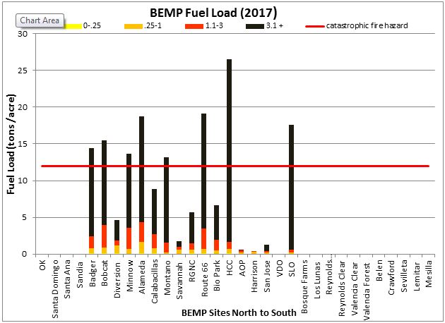
2017 fuel load analysis using BEMP’s developing program for the Albuquerque BEMP site
Each winter since 2004, BEMP has been conducting woody debris surveys. We visit each of our sites and survey 10 established transects, or lines, within the sites. At each transect we count the number of small (0-.25in), medium (.25-1in), large (1.1-3in), and extra large (3.1in +) sticks or logs that have fallen. We also measure how high the dead and down sticks pile up as well as the depth of leaves and wood chips that have accumulated on the forest floor. We then use all of this to calculate fuel load in tons per acre. The fuel load calculations have the potential to assist with fire prevention and management in the bosque.
The BEMP team is currently working to develop a program that can accurately calculate fuel load for a riparian forest. Many of the existing programs only calculate fuel load for mountainous ecosystems and we need something more specific to our bosque. From our program, we are able to construct a scale that estimates the potential fire risk and provide our data users and local land managers with the most up-to-date and accurate information on potential fire risk. The risk-scale takes into account the type and size of the woody debris, ease of access to the area, and the amount of human foot traffic.
So next time you enter the bosque, as you veer off the beaten path, I encourage you to pay close attention to the forest floor. Do you see a lot of woody debris? Does the amount of woody debris change between different regions of the bosque? Think to yourself, if a fire ignited here, where will it go, and is there enough fuel for it to grow and grow?
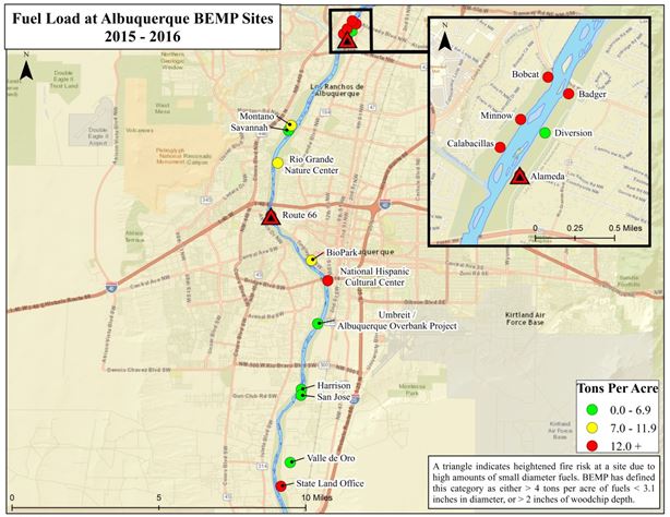
BEMP’s analysis of potential fire risk in the Albuquerque area. The site distinctions are a combination of parameters based on total fuel load, wood size & type, and the public’s ease of access to that area.
Blog Post by Sean O’Neill, BEMP Biologist